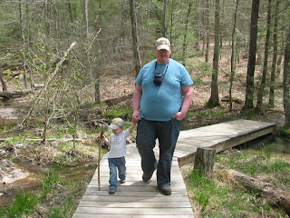
Yesterday our weekly hike took us to Kingsport, Tn to Bays Mountain Park and Nature Preserve. We had Logan in tow again, so it seemed like the perfect relaxing little day trip. We walked around and visited all the animals and birds, then hit the trail to the fire tower at the top of the mountain.
It seemed perfect. The trail alternated between flat, then slight inclines, and just a few bigger hills. We encountered countless squirrels and one garter snake who was very unhappy with us for walking by him. Roots of the trail side trees showed through the ground, making beautiful designs where they crossed over one another and jutted in and out of the ground. There were quaint little foot bridges and this one striking tree that looked like it was sculpted.
We all moved along at a good pace until we moved off of the Lakeside Trail and on to the Fire Tower Trail itsself.
Let me just say that as much as last week's hike was a disappointment, this week we made up for it with steep hills with almost sand-like trails that cause our feet to slip. The picture above is the last picture I took of the trail because I was concentrating more on just getting to the top so we could come back down. On top of the challenge of the trail, we made the rookie mistake of not taking enough water. I had slipped a 32 oz bottle that I had been sipping on into my bag, thinking I had barely had any of it, but didn't pay attention to the fact that there was only about 1/4 of the bottle left. I tried my best to ration it, and we didn't touch it until we were almost to the top. We each took a sip, and an extra for Logan, and that left just enough for a drop on our tongues at the top.
 One we got there, I decided to sit with Logan while Nate climbed the tower. I was going to go up after him, but the steps were loose and rickety, and my legs were a little rickety in their own right, so I resolved to stay on the ground.
The nice clear picture of the mountains is one that Nate took from the tower. On the ground, we couldn't see quite as much for the trees. But we had our own veiw of what I am assuming is the Holston River.
 The trip down was, as you would expect, easier. We were all tired and thirsty, and ready for dinner. Logan crashed out on Nate's shoulder, which I wished we all could have done. We made it back about 45 minutes before the park closed. Then we rebuilt our strength with chick-fil-a, and, for Logan and I, a fantastic bowl of coffee, caramel, and marshmallow frozen yogurt (topped with graham cracker crumbs, cheesecake bits, caramel drizzle and a brownie chunk!) from Sweet Frog.
This week I plan to concentrate through the week on building up a hiking pack to take with us every trip and which will be used exclusively for that purpose. This should ensure that we do not end up out with no water again. And also, I will be trying to be more active through the week, because if I learned one thing yesterday it is that boy oh boy am I out of shape!
According to the map from Bays Mountain, we hiked a total of about 3 1/2 miles yesterday. Elevation at the base of the Fire Tower is 2,405. Elevation at the Kingsport Reservoir, where our trail began is 1,835.
http://www.baysmountain.com/
http://www.baysmountain.com/wp-content/uploads/2011/12/Visitor_MapOpt.pdf


No comments:
Post a Comment